|
|
|
|
 |
|
 |
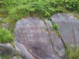
Originally written in red grease, this is arguably Canada's most significant graffito.
SECTION 8 THE INTREPID ALEXANDER MACKENZIE AND THE NOR'WESTERS
The Mackenzie cousins-Alexander and Roderick-were successful fur pedlars from Detroit, who joined the trading consortium known as Gregory, McLeod and Co. in 1784, as rivals to the North West Company. Their first year of company trading was spent at Lac Ile-à-la-Crosse, but the antagonism arising from the bitter relations between the members of the two companies prompted them to amalgamate in 1787. The enlarged North West Co. was now the chief competitor of the Hudson's Bay Co. until their subsequent amalgamation in 1821.
Arguably the North West Co.'s most colourful character was Peter Pond, in his wanderings as a fur trader, while keeping one step ahead of the law after committing murder. A rabiator perhaps, but he was also the discoverer of the Alberta Tar Sands and the first to map the Mackenzie River System. He is also credited with developing the trade in Pemmican, which was soon to become the staple diet of many explorers and fur traders.
While his first cousin, author Roderick Mackenzie, was sent to establish the important post, Fort Chipewyan, which became the principle post (with a 2,000 volume library) of Lake Athabaska, Alexander Mackenzie (1762-1820) left Ile-à-la-Crosse meanwhile to replace Peter Pond as Factor at Old Fort Pond and take charge of the Athabaska District. During the next twelve years, many posts were established under Mackenzie's direction in the northern Canadian interior and much information was gathered by Company trader/explorers regarding the geography of the region. It was while at Old Fort Pond during the winter of 1787, that Pond gave Mackenzie information regarding his summer explorations around Great Slave Lake and the source of the great river that Mackenzie was to follow.
On 3 June 1789 Alexander Mackenzie led a small party on an expedition to follow Pond's great river which he hoped would lead them southwest to the Pacific. Twenty-six days out they found the river's exit from Great Slave Lake. Having passed through the territory of the Copper, Slave, Dogrib and Hare Indians of the Athabaskan or Dene Nation, and discovering the oil and flaming lignite region of Norman Wells, Mackenzie arrived at Whale Island in the Mackenzie Delta. There, observing the rising tide swamping his baggage, he correctly deduced that he had reached the Arctic Ocean, but not the Pacific. His lack of knowledge in celestial navigation prevented him identifying his position accurately. He retraced his steps up the river he named 'Disappointment', which is known today as the Mackenzie River, back to Fort Chipewyan - a round trip of 3,000 miles in 102 days.
Between 1790-92 Mackenzie betook himself to London determined to improve his surveying, cartographical, astronomical and navigational skills. Meanwhile the Hudson's Bay Company sent their surveyors Philip Turnor, Peter Fidler and Malcolm Ross to survey the North West Company routes to Lake Athabaska and Great Slave Lake.
Upon returning to Canada, Mackenzie determined to embark on another great overland expedition to the Pacific Ocean, this time making it to the Pacific Ocean, (literally a red letter day for Canadian history.) His discovery of an overland route from the interior to the Pacific won him a knighthood following the publication of his 'Voyages',(1801) but it was not until the 20th. century that his prediction of the commercial viability of the Mackenzie River and its adjacent mineral wealth was fully vindicated.
|
 |
|
 |
|
|
|
|
|
 |
|
 |
Mackenzie's 'Voyages' is said to have influenced Lord Selkirk, among others, in choosing Western Canada as a desirable place for settlement. It is known that the two consulted prior to the foundation of the Red River Settlement.
Because of the length, difficulty and expense of a trading expedition from Montreal, via Fort Chipewyan, to the Pacific Mackenzie suggested that the Hudson's Bay Company (H.B.C.), the North West Company (N.W.Co.), and the East India Company seal an agreement, but this greatly irritated his partners.
Dissatisfied with the management of the N.W.Co. and believing he had enough influence to establish alternative trading alliances with the Dene Indians, Alexander Mackenzie left the N.W.Co. to join the rival 'X-Y Co.' syndicate in 1799, and for the next four years he traded for furs in fierce competition with the N.W.Co. and the H.B.C. In 1804, however the 'X-Y Co.' made a corporate merger with the N.W.Co. and Mackenzie retired to sit as MP. for Huntingdon. In 1808 he returned to Scotland. Where even there it was mostly about the money. At aged 50 he took as his wife his beautiful and wealthy 14 year old cousin, Geddes, (as well as discreetly supporting his North American ‘country wife’ Catt.) and profitably managing his considerable estates.
The continent turned out to be larger than imagined on early maps, and the final part of the journey was made on foot instead of water, but the boundaries of the continent were now established from the Atlantic Ocean- to the Arctic Sea- to the Pacific Ocean.
The N.W.Co, had now established a monopoly in the fur trade in the northwest interior of Canada with its headquarters in Montreal and transfer depôt at Fort William (Thunder Bay). Its French Canadian, Métis and Indian voyageurs transported the economy of northwest Canada on their backs, along the principal water trade routes of the region.
The H.B.C. meanwhile, continued to confine itself to trading into Hudson's Bay and vicinity, primarily due to lack of manpower (employing less than 500 persons in Canada in 1799). With expansion inland throughout the Hudson's Bay watershed however, fierce competition and violence were to come in the first quarter of the next century along with increased profits for both the H.B.C. and the Nor'westers and disease and disruption for the first nation peoples.
RERENCES CITED:
Mackenzie, Alexander. Voyages from Montreal on the River St. Lawrence through the Continent of North America to the Frozen and Pacific Oceans in the Years 1789 and 1793. With a Preliminary Account of the Rise, Progress and Present State of the Fur Trade of that Country (London: Printed for T. Cadell and W. Davies [etc.] by R. Noble, 1801.
Cook, A., Holland, C. The Exploration of Northern Canada 500-1920 A chronology. Toronto 1978. 1792-3
Alexander MacKenzie
|
 |
|
 |
|
|
|
|
|
 |
|
 |
Relevance of Mackenzie's and Northwest company explorations :
- Many posts were established under Pond’s and Mackenzie's direction in the northern Canadian interior and much information gathered by Company trader/explorers regarding the geography of the region.
- Trade in Pemmican, which was soon to become the staple diet of many explorers and fur traders was established.
- The oil and flaming lignite region of Norman Wells was discovered.
- North West Co. was the chief competitor of the Hudson's Bay Co. until their amalgamation in 1821.
- The boundaries of the continent were now established from the Atlantic Ocean- to the Arctic Sea- to the Pacific Ocean.
- Alexander Mackenzie was the first European to cross the continent of North America north of Mexico overland from the east, with the help of Indian guides.
- Mackenzie was the first white man to discover the 6000ft. altitude Mackenzie pass
- The Mackenzie Trail stretches 347 kilometres through central B.C.
- Marked the onset of overland fur trading in British Columbia coincidental with the decline of the maritime-based sea otter trade.
- Mackenzie imagined nothing less than combining, under one corporate umbrella, “the fishing in both seas, and the markets of the four quarters of the globe. Such would be the field for commercial enterprise, and incalculable would be the produce of it.”
- Lord Selkirk, among others was influenced, in choosing Western Canada as a desirable place for settlement.
- U.S. President Thomas Jefferson read Voyages from Montreal in 1802 and initiated the Lewis and Clark expedition.
|
 |
|
 |
|
|
|
|
|
|
|
|
PLEASE NOTE THAT THESE ITEMS MAY ONLY BE PURCHASED AS A COMPLETE SECTION
Four Items >ASRL PRICE CODE G Contact us
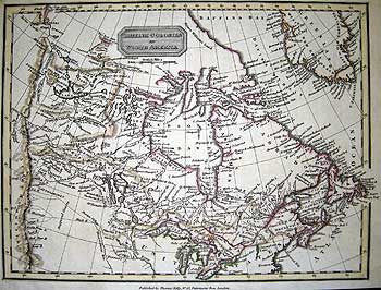
MACKENZIE - British Columbia/Alberta
A MAP of MACKENZIE'S TRACK from FORT CHIPEWYAN to the PACIFIC OCEAN in 1793
ALEXANDER MACKENZIE London 1801
First state; Copper engraved map, linen backed fair condition, 22 x 23 ¾" (56 x 60.3 cm) Ref. /DLN/ >DNNN
A first state of the important map published in Alexander Mackenzie 'Voyages....through the continent of North America to the Frozen and Pacific Oceans.... London 1801, this map delineates the territory through which Mackenzie travelled on his historic 102 day journey, to the Pacific Ocean and back.
A seasoned N.W.Co. traveller, Mackenzie believed in travelling light with a lean entourage (nine men, one dog, a 26 ft. canoe and 3,000 lbs. of supplies). Having returned from two years in London, and confident in his newly acquired survey skills, he departed Fort Chipewyan (founded 1788) with his party accompanied by native guides on 10 October 1792, with the aim of discovering an overland route to the Pacific, and ascertaining whether in fact there was an inland Northwest passage in a low latitude. (Mackenzie's and Vancouver's explorations finally quashed that long-held dream.)
Mackenzie ascended the Peace River as far as Fork Fort, at the confluence of the Peace and Smoky rivers, to which Mackenzie had sent two men the previous autumn in order to begin construction on the buildings prior to his arrival. Officially establishing the post, Mackenzie's party over wintered there, departing 9 May 1793.
At Finlay Forks on Williston Lake, he wisely chose to ascend the Parsnip River to its source, rather than continue along the Finlay. Crossing the 817 yard continental divide, he connected with the treacherous upper reaches of the Fraser via various creeks and the McGregor River. Incorrectly believing the Fraser River to be the Columbia River, he descended it as far south as present day Alexandria. On the advice of the local Nuxälk-Carrier Indian guides, Mackenzie returned north to a point just south of present day Hixon, where he struck westward, travelling overland by following the native ‘Grease trail’ (oolachan oil native trade route) into what is now Tweedsmuir Provincial Park (near Stuie). [Note: For ease of interpretation of his route modern nomenclature has been used rather than that on Mackenzie’s map]
Crossing over the Dean River he proceeded south to join with the Bella Coola River. Without the guidance of Indians, Mackenzie would have been unlikely to reach the Pacific shore. [224 years later this is still a very rugged trail route and not for the faint of heart.]
|
|
|
|
|
|
|
|
|
|
|
|
Mackenzie, realizing the significance of his journey, understood the importance of ascertaining an accurate measurement of his latitude. Therefore, instead of resting at Bella Coola village on the tidewater inlet of the North Bentinck Arm (a coastal Fiord), although much tormented by the miasma of flies, he insisted on taking a canoe down the arm to the Dean Channel. On a rock in Elcho Harbour he proudly proclaimed his furthest west to be in 52°30' 48" Lat. N. by inscribing on a rock, with a mixture of bear grease and vermillion (salmon roe) face paint, the immortal words "Alex Mackenzie, from Canada, by land, 22nd. July 1793". As a N.W.Co. partner and now the first European to have reached the Pacific Ocean overland from the east, he clearly wished to distinguish himself from any H.B.C. expedition to the Pacific which would have originated from Hudson Bay.
While at Bella Coola village he was informed that another white man, George Vancouver (see section 7), had arrived in the same area just seven weeks earlier. Coincidentally at the same time, Vancouver's elder brother Charles, was in London attempting to raise money for an overland journey similar to Mackenzie's. After only one night, having replenished his dangerously low food stocks, the intrepid Mackenzie turned for home, reaching Fort Chipewyan in only 33 days. There he rested for the winter.
Alexander Mackenzie was the first European to cross the continent of North America north of Mexico by land, with the assistance of Nuxälk-Carrier guides during the momentous spring and summer of 1793. To put his journey into international context: the terror of the revolution raged in France with the execution of the King and Queen amongst many others, heralding the rise to power of Napoleon. Elsewhere, the Capitol building was begun in Washington, as was the White House. Eli Whitney invented the cotton gin and Denmark was the first country to abolish slavery.
The publication of Alexander Mackenzie’s Voyages from Montreal in 1801, including an uncredited history of the fur trade by his bookish cousin Roderick Mackenzie, marked the onset of overland fur trading in British Columbia coincidental with the decline of the maritime-based sea otter trade.
Had subsequent fur traders realized that the virtually unnavigable upper reach of the Frazer River was not in fact the Columbia, they probably would have explored further south and extended British possession into the Oregon country prior to the arrival of the Americans, thereby extending the borders of present-day Canada.
An error on this map in the spelling of Mackenzie's name appears beneath his dotted track to the sea.
Ref. Sabin J. Bibliotheca Americana, A Dictionary of Books relating to America. New York 1868-1936 #43414
Clements Research Catalog of the maps of America to 1860 in the William L. Clements Library. Edit. Douglas W. Marshall. Boston 1972. Vol 2, p.3.
|
|
|
|
|
|
|
|
|
 |
|
 |
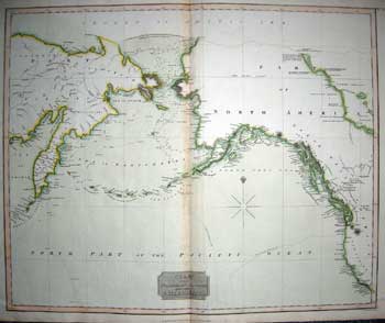
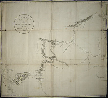
NEELE- Pacific Coasts of Asia and America
CHART of the NORTHERN PASSAGE between ASIA and AMERICA
SAMUEL J. NEELE Edinburgh [1815]
Body and outline coloured copper engraved map on wove paper
19 1/2 x 23 1/4" (49.5 x 59.3 cm.) Ref.LRAm1078/DNN/0.dosl>GNN
Drawn and engraved by Neele, but published in John Thompson New General Atlas, #74, Edinburgh 1814 (1817) and based upon the later states of the Faden/Roberts chart. This pleasingly coloured map shows the extent of knowledge gained throughout the eighteenth century by Russian, British, European and American explorers and fur traders along the Pacific coasts of Asia and America and the coastline is now delineated. By this time most of the Aleutian Islands and islands in the Bering sea have been delineated with the exception of the Nunivak and Pribilof Islands. The tracks of Captn. Cook’s ships are shown, commemorating the particular importance of that voyage of exploration and those additional details added by the exploratory voyages of his protégées. Along the coastline, place names and topographical features are named as far south as the Kamtchatka peninsula in Asia and San Clemente Island in California.
The northern coastline of Alaska and Canada is yet to be delineated with the exception of the Mackenzie River and delta which are shown as fixed points, also the track of Mackenzie's 1793 overland crossing of the continent is rudimentarily marked.
The Pacific northwest coast line had now been delineated, the continent traversed by land. Exploration now focused on the delineation of the Arctic. With the Napoleonic wars finally at an end, a new era of exploration was about to unfold. The focus of exploration was to be a North West passage, not for its commercial possibilities (almost another two centuries were to pass before technology and climatic conditions could begin to realize its potential.) but the possibility of obtaining new geographical knowledge, scientific investigation and awareness of the natural history of the region. Fame, if not fortune, plus the incentive of promotion in a navy top heavy with competent officers, was enough to quicken the blood of many an Englishman with a lofty sense of purpose.
Ref: Phillips Atlases, 731
Kershaw Early Printed Maps of Canada. Ancaster 2002 Vol. IV entry 1152
|
 |
|
 |
|
|
|
|
|
|
|
|
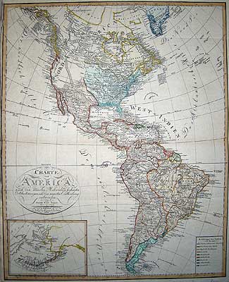
STREIT- North and South America
CHARTE von AMERICA nach den neuesten Materialien sichersten Ortsbestimungen und der neuesten Eintheilung entworfen.
Inset: [Pacific Northwest]
FRIEDRICH WILHELM STREIT Wimar 1810
Scarce, copper engraved map with original colour. Printed on heavy laid paper. Left hand margin cut close, otherwise in good condition.
22 7/8 x 18 ½" (58 x 46.7 cm.) Ref.LRA 1123/AAS/a.dnsg> ONN
This fascinating, elegantly engraved, early German printed map of the Americas neatly displays a wealth of interesting nomenclature and topographical features, including the Gulf stream. This an early map to show western American native Indian tribes in the newly acquired Louisiana purchase (1803). West of that territory, the interior of North America is largely blank marked Stadthalterschaft apart from the Rocky Mountains and coastal place names, but in British America or northern Canada there is a surprising amount of detail for the period, with many lakes and rivers delineated. Although Mackenzie’s 1793 track does not appear to the coast, the newer trading posts to Finlay Forks and the height of land are marked.
It is possible that Aaron Arrowsmith's 1802 map of "North America- New Discoveries" was used as a base; however, the most striking feature of Streit's map is a curious isthmus in the Arctic regions between the Icy sea and Baffin's Bay, its origin probably stems from Müller's 1754 map
Further, two unusual kidney-shaped lakes flank the Mackenzie River Delta with the note, in German "two large lakes are known to the Indians."
A colour coded key gives the territorial holdings of the European powers. The map also has an attractively engraved title cartouche.
The inset of the Pacific Northwest has Bering strait titled ‘Beering and Cooks strasse’ [sic] also St. Lawrence Island shown as Clerks Is. Although known for centuries to the indigenous Aleuts, the Pribilof Islands were discovered in 1788 and are here delineated, as are the Catharina Archipelagus (Aleutian Islands). A manuscript addition would seem to indicate that a west coast voyage was planned via the Columbia River, Norfolf Sound (Sitka), Kodiac Island and Russia from San Francisco.
In all, a most interesting and handsome map, which has become very scarce today.
Friedrich Wilhelm Streit (1772 -1839) was a Viennese born mathematician, military cartographer and ober-lieutnant engineer in the Prussian Artillery Corps, from 1807-10 he was director of the Geographical Institute in Weimar.
To purchase the original antique Maps and Prints of section 8 Contact Us
© Darrell G. Leeson MMXVII
|
|
|
|
|
|
 |