Since 1763 the name 'Russborough' has been synonymous with collecting and dealing in fine art. In the closing decades of the last century the historic town of Port Hope has become home to Lord Russborough's Annex, which specialises in an individual mix of antique maps, paintings and prints.

While Lord Russborough's Annex features a great many works of museum calibre, we also offer a wonderful selection of prints priced at under $100.

 Scroll page to view manuscripts available

An extract of our Manuscripts currently available:

Siege of Quebec

Antiphonal
Book of Hours
Illuminated Spanish Legal Document 1582

SINK THE BISMARCK WWII naval signals

W.T. Kains. MS letter from HMS. Victory
W.T.Kains Certificate of Service 1853


Baldwin Family Indenture
Peppercorn Rent Indenture 1784
Canadian Crown Land Sale 1865

Marshal Ney Waterloo Dispatch
Napoleon Letter to Comte Mollien

Lord Paget Letter

Abraham Lincoln receipt 1833 - Forgery

Farley Mowat draft Typescript The Farfarers
Charles Dickens Letter

Sir Walter Scott - Lord Byron poem

Collectable Autographs

Siege of Quebec

A MANUSCRIPT OF NATIONAL SIGNIFICANCE TO CANADA
Plotting of the French positions.

MACKELLAR- Quebec City

'A Description of the Town of Quebeck in Canada, accompany'd with a plan'

Thirteen pages folio on Anglo-Dutch watermarked Van Gerrevink laid paper, written in ink in a copper-plate scribal hand, signed with the initials "P.M.", dated September 1756, with a postscript similarly initialed and dated 23 December 1757.

Together with: (in another Hand) 'PLAN of the TOWN of QUEBECK enlarged from the Plan published in Charlesvoix by Bellin, with Additions.'

Ink and colour body washes, manuscript map with keyed references below relating to the map and report.

Scale: 400 ft. to an inch. Within a ruled border. Good condition.
Mounted within a triple matt (two of museum quality), glazed, giltwood frame.

Size: 16 X 14" (40.6 X 35.6 cm.) Frame: 29 1/2 X 26 1/4" (75 X 66.7 cm.)

Price Code L: Click Here for Pricing Details

History

In the spring of 1756 Patrick MacKellar was appointed chief engineer of the British forts of Ontario and Oswego.

During August he was engaged in repairing and strengthening the frontier forts (formally Pepperell or Chouagen) on the Oswego River, when, on the night of the 10th. they were surprised and attacked by a French force of 3,000 men.

In spite of a heroic defence, the forts eventually surrendered during the afternoon of August 14. Sixteen hundred prisoners, including MacKellar and 79 other officers, were captured. MacKellar was taken to Quebec City as a prisoner of war where he was kept in fairly close restraint. He was able, however to make detailed notes on the city's defences, until some time in September when he was transferred to Montreal. In December of 1757, following a meeting with his fellow prisoner-of-war, Moss, it would appear that MacKellar had 
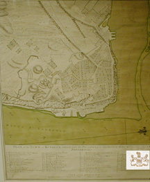
time to draw upon his notes in order to compile the above report and arrange the production of the map.

On a salary of a pound a day, the now Major and Chief Engineer, MacKellar accompanied General James General Wolfe, Supreme Commander of the British Land Forces in America, to attack Quebec.

In May 1759 the army of 8,535 men assembled at Louisbourg, renamed Pittburg in honour of the Prime Minister, (the fortress of Louisbourg, having been reduced by Amherst the previous year, during which siege MacKellar distinguished himself.)

During the siege of Quebec the intelligence contained in this report proved to be invaluable.

Despite being wounded in the attack from Montmorency, MacKellar scaled the heights of Abraham with Wolfe, and took over the command from Wolfe when he fell. Quebec capitulated on September 17.

Upon occupation by the British, Mackellar strengthened the defences, thus enabling it to withstand the 1760 French attempt to retake the city. Although MacKellar was severely wounded during the attack at Sillery, he later took part in the capture of Montreal and other engagements, thus completing the fall of France in Canada.

Mackellar also contributed much to the survey and defences of Halifax, and various engagements in the West Indies during the expulsion of the French, eventually being promoted Colonel and Director of engineers on Minorca.

THE REPORT AND MAP

This very legible 13 page folio report bearing MacKellar's initials was considered of the utmost importance by his commanding officer General James Wolfe and, SHOULD NOW BE CONSIDERED AS A DOCUMENT OF NATIONAL IMPORTANCE TO THE PEOPLE OF CANADA. Using the intelligence contained therein, Wolfe landed his men at Quebec and scaled the heights of Abraham.

BACKGROUND OF THE MAP: it is known that more than one manuscript copy was made at the time ( as would be expected as the report was under discussion by Wolfe's General Staff and the Board of Ordnance). Although differing from the copies held in the Public Archives of Canada (P.A.C.), the significant intelligence amendments contained in our accompanying report were not transferred to the reconnaissance map.

THE REPORT & MAP (of which we know of four contemporary copies; P.A.C. & B.M.) is compiled from MacKellar's notes, is written in a similar hand, which in view of MacKellar's rank, was probably scribal, but is remarkably akin to known examples of MacKellar's handwriting held in the Public Archives of Canada.

Our copy has a lengthy and highly significant postscript not included in the other copies.

The report is dated September 1756. It contains information drawn from Mackellar's experiences whilst a prisoner-of-war in Quebec, from August 1756 and prior to his transfer to Montreal and eventual release in the exchange of prisoners in the spring of the following year, and bears the initials "PM"

THE POSTSCRIPT (dated and initialed 23 December 1757) details six extra points containing important new intelligence.

The contents cover significant modifications and reinforcements to the town's defences subsequent to MacKellar's departure which updates the information in the main body of the report, and includes additional topographical information, modifications to the fortifications and a substantial increase in the number of opposing troops, the postscript is clearly dated 23 December 1757.

This important intelligence is not contained in any other copy of the report of which we are aware, and follows on from the main body of the report (dated and initialed September 1756).

In all, both the map and the following extracts from the report hint at an illuminating account of:

The Topography of the town and Heights of Abraham:

"The greatest heights of the cliffs is a little above and below the redoubt of Cape Diamond, where it must be at least 200 feet high, it falls from thence in several easy breaks..."

"The Low Town on the east side is a fair object for both shot and shells from shipping, the buildings are in general high and pretty close."

The Means of Communication Between the Two Parts of the Town:

"There is a break in the cliff westward of the 8 gun battery marked '4' where four or five people may pass abreast, it is pretty steep and may be easily secured."

Its Land and River Defences:

"Battery '4' consists of 57 guns but to the anchoring ground points only 36."

"...To the hangman's redoubt 'W' is a small wall of masonry three or four feet thick and seems to have been designed only against small arms..."

"I am persuaded from all the circumstances I could learn that the place must be weak towards the land and the difficulty they made of our seeing it seems to confirm it..."

Suggested Plan of Attack:

"...In the passage down the river we met only with two difficulties worth mentioning and they were observed by Charlesvoix and in the chart lately published by Mr. Jefferys."

Secret Weapons of the French:

"...An invention the French had discovered for infallibly destroying ships going up the river."

Landing of the Troops:

"...It will be an advantage to land the troops on the townside of the River which is the North but I am very doubtful whether their landing within proper distance of the place can be cover'd by the shipping..."

"...For these reasons I should think it most advisable to land upon the island itself and make it a rendezvous..."

A leaf from an Antiphonary.

THIS MANUSCRIPT IS OVER 550 YEARS OLD.

UNIQUE. Double sided antiphonary manuscript from Flanders Northern France. Ca. 1450.

A WHIMSICAL CARICATURE, traditionally a portrait of the Scribe, in the initial of his name on the Recto makes this unique piece particularly desirable.Small mediaeval Antiphons, such as this, are rare as they were for private, rather than communal, use.
Usually commissioned by a member of the Aristocracy who had taken holy orders.

AN ILLUMINATED LETTER 'U' decorates the Verso Gothic textura quadrata script and black letter musical notation in black ink and rubrics and four~line staves in red. Each Versal and Response begins with a four line initial, embellished with delicate tracery works.

Page size 10 X 6 3/4" (25.4 X 7.1cm)
[Ref DGL1236/AVL>OOL] Price Code B: Click Here for Pricing Details   SOLD


Recto

A LEAF FROM A BOOK OF HOURS

Anonymous Dutch, first half of 15th Century.

Among the most frequently produced manuscripts of the 15th. century were the Book of Hours . Though based primarily on the offices chanted by monks and nuns, the Book of Hours served the spiritual needs of pious lay men & women who frequently commissioned scribes and artists to prepare such prayer and devotional books to their individual tastes, and purse.

Highly skilled scribes, themselves mainly monks or nuns, often took painstaking care in producing these, usually small or miniature, books (in order that they might easily be held) in a wide range of style and elegance from the quite plain to the richly illuminated and adorned as in the example of the Hours of Jean, Duc de Berry.

Today scholars, book lovers and collectors alike appreciate these examples from Books of Hours not only for their beauty and rarity but also for the fact that we can learn much about medieval life by studying the illuminations that decorate their pages, indeed as many of the passages concerned tasks to be completed at certain times of the year Book of Hours became the precursors to modern almanacs . While illustrations drew from Biblical passages for their inspiration, others drew from the elements of ordinary life in the middle ages . Thus these artists decorated their pages with domestic scenes taken from their knowledge of familiar towns. farms and castles that surrounded them with a profusion of flowers fruits, animals, and insects

UNIQUE. Leaf on vellum, from a manuscript Book of Hours. Scripted & illuminated in original colours on each side of leaf. Double museum quality matted. In excellent condition a most attractive leaf, glinting with the burnish of real gold.

RECTO: 20 lines of manuscript text, 1 five-line capital "G" God in burnished gold and original hand painted colours, 1 two-line initial in painted colour and 6 one-line initials in same. 20 manuscript lines of Dutch text written in black and red ink in Gothic textura quadurata script. Three-sided illuminated border of gold flowers & styalized leaves sprouting from a single bar border (left) of burnished gold & painted colour.

VERSO: 20 lines of manuscript text, I two-line capital "H" Heve. in original hand painted colour, 1 one-line initial in same.

Size of leaf 51/2 x 41/4" (140 x 108 mm)

Ref LRA-AF 45 AG /LSO/snnn>DRLN
Price Code E: Click Here for Pricing Details    SOLD

Original Naval Signal Order to Sink The Bismarck

SINK THE BISMARCK!

[The original incoming and out going naval signal order to sink the German pocket battleship Bismarck during the Battle of the Atlantic.]

The incoming signal: "Most Immediate to HMS. Dorsetshire from SO 1st. C. S."
reads: "Torpedo Bismarck close range. -1022B. received at: 1042 on 27 /5/41"

 This is the original carbon incoming signal, known as a ‘Flimsy’ as taken down by the wireless telegrapher W/T Paul Johnson on board heavy Battle cruiser HMS. Dorsetshire, - at 1042 the morning of 27 May 1941.
The final engagement to sink the Bismarck having commenced about two hours earlier, and is well documented in the annals of British naval history. The 10 minute difference between the signal being issued from Rear Admiral Wake Walker, Senior Officer 1st. Cruiser Squadron on board the Battlecruiser  HMS. Norfolk  (Capt. A.J. L. Phillips) and received on the Dorsetshire  was normal.
The outgoing copy of this signal from the Norfolk  is housed in the PRO London.

------

The original reply being the graphite outgoing signal oft referred to as a ‘Cover’ reads:

BN874 - X329 - Most Immediate
to C & C HF from HMS.
Dorsetshire reads: I Torpedoed Bismarck both sides before she sank . She had ceased fire but her colours were still flying. -1107
the reader in this case was Bloxon and the time of receipt 1214.

Both signals are hand written manuscripts on the standard Naval message pad S1320c.
(printed in June 1940.) Paper size 11 x 8"

The latter IS THE ORIGINAL OUTGOING SIGNAL from Capt. Benjamin C.S. Martin HMS. Dorsetshire, to Admiral Sir John Tovey Commander-in-Chief Home Fleet  received on board the King George V (Capt. W.R. Patterson)   as such, it  is one of the most significant British naval signals of World War II and most certainly of the Battle of the Atlantic.

Interestingly, the hour difference between time of sending & receipt of this outgoing signal is unexplained, unless by events of the moment.  Initially the Dorsetshire having acknowledged the execution of its order, proceeded to pick up survivors, until the presence of a U-Boat necessitated departure from the area. Further, the inclusion of the phrase “her colours were still flying” showed that even in time of heavy fighting it was deemed necessary to observe the British protocol of naval warfare. One didn’t fire upon an enemy ship once she had struck her colours. The ‘Pocket’ battle ship Bismarck (Kapitän zur See Ernst Lindemann) with Fleet Commander Admiral Lütjens on board, was the newest warship and the pride of German naval architecture, following the sinking of the pride of the British Royal Navy the Battle cruiser HMS. Hood, the chase to sink the Bismarck covering a million square nautical miles, and the number and strength of the ships deployed against her, is perhaps unique in naval history. Some 64 vessels and 2,878 shells were fired at her, pulverized, she still refused to die. Dorsetshire fired the last 2 projectiles from close range 3000  (3300 yards) starboard side with a hit below the bridge, and another astern, and at 1036 from the closer range 2200 meters (2400 yards) port side, the final torpedo.  Bismarck  sank three minutes later, whilst also being scuttled. There were 110 survivors and 2090 lost.

Provenance: by Descent from Paul Johnson

(Ref. MK1a&b/LLN>DLNN/l.ng >AANN)                PRICE CODE F   Click Here for Pricing Details    SOLD

Return to Naval Listings

Return to Top

TORONTO FAMILY COMPACT INDENTURE

Baldwin MS complete


Manuscript Indenture between William Warren Baldwin and Daniel Simmons, dated 2 April 1835,
Regarding a sale of land being two lots at the northwest corner of Spadina and Dundas St. [formerly St. Patrick Street.] for £60.

Written in iron gall ink on parchment with accompanying red wax seals and signatures of William Warren Baldwin, Daniel Simmons, parties; Adam Wilson, John Hector, witnesses; and Samuel Smith Ridout, registrar.


The value of the property £60, in 1835 translates to an equivalent of £60,360.00 or US $118,925 today, using the per capita GDP. of the day.
William Warren Baldwin, Adam Wilson, John Hector, and Samuel Smith Ridout, were all members of the ruling oligarchy generally known as the Family Compact  which had tremendous influence in pre-rebellion Upper Canada and particularly the development of Toronto.
Daniel Simmons, was listed in the Toronto register alternatively as a Bricklayer or Carpenter between 1835 & 1846.
The appeal of this fully documented manuscript lies in:

  • The signatures of prominent citizens of pre-rebellion Toronto
  • Interest to collectors of Baldwin papers
  • History of Toronto properties

baldwin_ms_sig

25 5/8 x 27” (65.2 x 68.6 cm.)

                
Ref. DK1/DNNN/d.annv >DLNN                PRICE CODE  E      SOLD

Click Here for Pricing Details

Return to Top

peppercorn rent indenture 1784

ORIGINAL BRITISH PEPPERCORN RENT MANUSCRIPT INDENTURE

written of parchment with six wax seals and two blind stamp seals dated 1784
18 1/4 x 25 1/2"
Matted, glazed, gilt-wood frame 22 1/2 x 29 1/2"
Ref. JG1 (45)/ ENN/ l.anns> GAL  PRICE CODE C

Crown Land sale 1865

CANADIAN CROWN LAND SALE
15 Nov 1865  160 acres to James Burton Lot 27 Mansfield twnsp, Pontiac Co. with waxed paper seal top left signed by assistant commissioner for Crown Lands  A. Russell.

Glazed,  black-wood frame.  14 1/4 x  19 1/4" (36.2 x 48.9 cm.)   Frame 18 5/8 x 23 1/2"
Ref. RM16 (205) /RN/ d.anar>VL    PRICE CODE A