Since 1763 the name 'Russborough' has been synonymous with collecting and dealing in fine art. In the closing decades of the last century the historic town of Port Hope has become home to Lord Russborough's Annex, which specialises in an individual mix of antique maps, paintings and prints.

While Lord Russborough's Annex features a great many works of museum calibre, we also offer a wonderful selection of prints priced at under $100.

Ross 1st arctic command

An extract of our prints currently available:
Index

10. John Ross First Arctic Command

Ross istcommand neg


SECTION 10  JOHN ROSS FIRST ARCTIC VOYAGE 1818

Sir John Ross (1777-1856) was a native of Inch, Wigtonshire, Scotland. From the age of eleven, some claim he was nine, when he went to sea, his career was tumultuous, spanning the French Revolution and Napoleonic eras, during which he was wounded thirteen times, Ross went on to become an eminent Arctic explorer. He led three Arctic expeditions, for which service he won promotion to Rear Admiral, and was knighted in 1834. He was later appointed British Consul to Stockholm and was a noted biographer, naval historian, phrenologist and inventor of the 'Royal William' sextant.

He commanded his first expedition to the Arctic under Admiralty orders in 1818, leaving London April 18th. with the 385 ton H.M.S. Isabella (crew of 57) and the 252 ton H.M.S. Alexander (under Lt. Wm. E. Parry with a crew of 37).

In keeping with the newly-felt European sense of responsibility towards environmental study at the dawn of the Industrial Revolution, this was the first of a wave of voyages to the Arctic in which the goal of the attainment of scientific observation and knowledge was considered to be equally as important as the attainment of either the Pole or the Northwest passage. On board was Ross's nephew, James Clark Ross (midshipman) and the expedition also included such specialty officers as John Bushnan (marine survey and draughtsman), Capt. Edward Sabine Royal Artillery (mathematician and astronomer), Alexander Fisher (mathematician and natural philosopher) and Lieutenants Hoppner and Beechey (artists/draftsman). These were all part of an elite, if small group of officers who were to dominate British Arctic exploration for the next forty years. The ships were equipped with the latest scientific instruments including azimuth compass, repeating circle, dip micrometer and atmospherical electricity apparatus.

John Ross's command was part of a two-pronged discovery effort. The other expedition, under the command of Capt. John Buchan and Lieutenant John Franklin in the Dorothea and Trent, was a direct attempt to attain the North Pole, sailing north from Spitzbergen and thence over the Pole to meet Ross’s expedition in Siberian waters. This attempt was inspired by whaler William Scoresby, jr. who reported little ice in the polar region for two successive years and that the east coast of Greenland between Lat. 70° and 80° N. was free of ice for the first time in 400 years. Nevertheless as with Phipps (See section 3) heavy ice was to thwart their plan. Sir John Barrow, Secretary of the Admiralty, with the support of naturalist Sir Joseph Banks (See section 5) together with that of The Royal Society, proposed that an Arctic expedition be undertaken "for the advancement of every branch of science... in short to lose no opportunity of acquiring new and important information"* an action which inaugurated a new era of arctic discovery that produced more knowledge of the region than had been achieved in the preceding centuries. Ross was instructed to find a Northwest passage, note the tides, currents, ice conditions, effects of magnetism, and to collect specimens.

Crossing the North Atlantic into Davis St., Ross's two ships were accompanied by a fleet of about 40 whalers. His two ships followed roughly the same course taken by John Davis in 1587 and once north of Sanderson’s Hope (near Holmes Island) on the Greenland coast, that of William Baffin in 1616. Ross was much impressed with the sightings of the early navigators. His 1818 expedition confirmed many of their early discoveries, including those of Baffin, for whom he had particular admiration, and Bylot (see section 4) which had previously been considered unfounded and had eventually been removed from most 18th. century maps. (see section 9)

In the Thule area, Ross met an Eskimo tribe which had not previously had contact with white men. Nevertheless, he missed an exceptional opportunity to gain a lasting fame, when he failed to properly examine Smith, Jones and Lancaster Sounds, believing them to be closed inlets due to a probable mirage, or ice blink, resembling thick cloud. Parry, however, was convinced that the latter might be a possible passage to the Arctic Ocean. Nevertheless, Ross, apparently without consultaton with his fellow officers ordered that the expedition turn back relatively early.

Returning to England on 16 November with geological and zoological specimens and many meteorological and magnetic observations, Ross reported that there was no Northwest Passage to be found in either Davis Strait or Baffin Bay. Sir John Barrow and the Board of Admiralty, despite acknowledgment of Ross's claiming of Baffin & Bylot Islands for Britain and his partial charting of their coastlines, considered the expedition a failure. Ross was refused further funds and was considered to have blundered "... and his acts and his book prove it”.* Ross and the Isabella parted company, but the Isabella was not quite done with him yet (see Ross’s 1829-33 voyage).

In later years whalers routinely followed Ross's 1818 course north to Baffin Bay along the Greenland coast and returning south along the Canadian coast. But it was Parry who was to reap the real benefit from this voyage.


*Barrow Sir J., Voyages of Discovery and Research within the Arctic Regions. London 1846, pp 11-12, 22.

References cited or consulted:
Historical Atlas of Canada Vol I From the beginning to 1800. University of Toronto Press. Toronto 1987.
John Barrow,  A Chronological History of Voyages into the Arctic Regions, undertaken chiefly for the purpose of discovering a north-east, north-west, or polar passage between the Atlantic and Pacific. J. Murray London 1818 and 1846 edn.
[T.P.L. 1152. Lande 1425. Sabin 73376. Hill p261. A.B. 14873. Abbey Travel 634. Ist edn book of above]
Lopez, B. Arctic Dreams C. Scribner's sons, New York 1896.
Sabin J. Bibliotheca Americana, A Dictionary of Books relating to America. New York 1868-1936
Cartographica. Explorers maps of the Canadian Arctic 1818-1860. Monograph No 6. York University, Toronto 1972.
Abbey J.R. Travel in aquatint and lithography, 1770-1860, from the library of J.R. Abbey : a bibliographical catalogue / [by J.R. Abbey 1896-1969 ]. Vol.1., World, Europe, Africa.
Cooke,Alan & Holland, Clive. The Exploration of Northern Canada 500-1920 A chronology.The Arctic History Press, Toronto 1978

The Relevance of Ross's First Arctic Voyage

• It was the first voyage to embrace a European sense of responsibility toward the environmental study of the Arctic.
• This was the first of a wave of specially equipped voyages, in strengthened ships, to the Arctic in which the goal of the attainment of scientific observation and knowledge was considered to be equally as important as the attainment of either the Pole or the Northwest passage.
• This voyage confirmed many of the discoveries of the early navigators such as Baffin & Bylot.
• Their counterclockwise directional track around Baffin Bay became the standard practice for subsequent voyages to the present day.
• His meeting with a previously unknown Eskimo tribe presented an opportunity for ethnographical study.
• Ross's failure to further explore Lancaster Sound led to a delay in the discovery of the Northwest passage.
• Further areas of the Arctic coastline were charted using more accurate measurement following the determination of Longitude and perfections to the marine chronometer.
• Various methods for the extraction of ships from the ice were tested and deployed knowledge which served later voyages well.
• This was the first voyage to employ the use of an Ice Pilot and Arctic native speaking interpreter.
• Ross's heavily illustrated expedition journal, with appendices became a model publication for subsequent British expeditions.

PLEASE NOTE THAT THESE ITEMS MAY ONLY BE PURCHASED AS A COMPLETE SECTION


Thirty eight Items >VGSN           PRICE CODE I                 Contact us

Note: The following charts and aquatints are from Ross John, A voyage of Discovery made under the orders of The Admiralty in His majesty’s ships Isabella and Alexander, for the purpose of Exploring Baffin’s Bay, and inquiring into the probability of a North-west passage. John Murray, London 1819.

Ross_1st bushnan chart

BUSHNAN - Davis Straight and Baffin Bay

A GENERAL CHART shewing the track and discoveries of H.M. Ships Isabella & Alexander to DAVIS'S STRAITS & BAFFINS BAY in an attempt to discover a passage into the Pacific Ocean. Commanded by Captn Ross RN. drawn under his inspection by John Bushnan midn. RN: 1818.

JOHN BUSHNAN London 1818 (1819)

Some offsetting. printed on wove paper. 9 1/2 x 17 1/4" (24.2 x 44 cm.)
Ref. LRA1101/DRN/ dd.dosl >ENN

Published in John Ross A Voyage of Discovery made under the orders of the Admiralty, in His Majesty's ships Isabella and Alexander London 1819, this shows a revised Greenland coastline based on the more accurate method of determining longitude employed since the establishment of the Board of Longitude. The track of Ross's ships along the coast of Greenland, Ellesmere and Baffin Islands  to 76° N is delineated without the possibility of any passage from Baffin Bay. Soundings and place names abound; the extent of the sea ice is also shown.  The discovery of Pond's Bay with its abundance of whales, brought large numbers of whalers to the 'West Water' area in subsequent years. This chart has now become hard to find.
Vide:Cartographica #6 Map 4

Ross 1st Walker Baffins Bay

WALKER - Melville Bay
PLAN of the PART of BAFFINS BAY which was found to be INHABITED.

JOHN WALKER London 1819

Some offsetting, printed on wove paper 9 1/2 x 9 1/2” (22.9 x 24.4 cm.)
Ref. LRA1130/DL/ l.dosg >DNN

Published in John Ross A Voyage of Discovery made under the orders of the Admiralty, in His Majesty's ships Isabella and Alexander, published by John Murray London 1819. John Walker (1759-1830) was engraver to the Admiralty. Shows part of Melville Bay on the west coast of Greenland (near present-day Thule airbase) with the track of Ross's ships and coastal features delineated.
It was in this area that the expedition fell in with some Eskimos who had never encountered white men or their technology before. It is reported that one of the Eskimos, through a southern Greenland interpreter, turning to H.M.S. Isabella herself, addressed the following questions, “Who are you? What are you? Where do you come from? Is it from the sun or the moon?”. Truly, he had just experienced a close encounter of the third kind!

Vide: Cartographica #6 Map 5

As with the foregoing, the following and some sepia tint aquatints were published in John Ross, A Voyage of Discovery made under the orders of the Admiralty, in His Majesty's ships Isabella and Alexander,  London 1819. They are rapidly becoming scarce, as illustrations from this first important voyage of the revival of Arctic discovery are now keenly sought. The following were engraved by Daniel Havell from drawings by J. Ross and published by J. Murray.

Ross-1st3 Gardie Hse

GARDIE HOUSE THE RESIDENCE OF WM. MOUAT, ESQ. 
Daniel Havell after A.M. Skene. Original grey tint aquatint.  6 3/4 x 9 3/8" (17.1 x 23.9 cm.) Ref. LRA arc 153/al/r.dosv>  DNN

This was drawn by A.M. Skene. William Mouat of [sic]Brassa / Bressay Island, Shetland, a friend of Ross's offered the ships' officers hospitality while they made scientific observations in the grounds of his estate. The observation tent may be seen to the left of the image. This was the expedition’s last land fall within the British Isles prior to venturing into Arctic waters. It was also the point of departure for the ships Dorothea (Capt. Buchan) & Trent (Lt. Franklin) in their search to attain the North Pole.  Published as plate # 1 in the above work.

Ross 1st-4Sawing through the ice

CREWS OF THE ISABELLA AND ALEXANDER SAWING A PASSAGE THROUGH THE ICE

Daniel Havell after John Ross. Original grey tint aquatint 6 3/4 x 9" (17.1 x 22.8 cm.)  Ref.LRA993p/an/da.dose> DVL

Daniel Havell’s was the first of many documentations of Arctic ships’ crews attempting the exhausting, bone-chilling work of sawing a passage through unexpected thick ice. Their nearby ships are shown moored to the ice with a kedge anchor. Published as plate # 7 in the above work.
Next morning at six, the ice opening to the North, we endeavoured [sic], by every exertion, to work towards the entrance of the channel, but had no sooner attained our object, than the ice again closed in upon us, and nothing was to be done unless by setting the crews to saw through the floes; but one of them continuing in motion, every effort was, for a long while, rendered fruitless, as it closed again as fast as it was sawed. In the evening, a narrow passage was effected, and both the ships were warped through with great difficulty. In passing along another narrow lane, as it were, further on, the Alexander was suddenly closed in; three boats were sent to her assistance; and after two hours' hard work, she was extricated.” [Ross, p. 62.]

Ross1st 5 Prrilious situation

PERILOUS SITUATION OF THE ISABELLA AND ALEXANDER
AUG'T 7th. 1818
Daniel Havell after John Ross. Original grey tint aquatint.
 6 3/4 x 8 5/8" (17.1 x 22cm.)   Ref.LRA992p/an/da.dose>  DVL


 A scarce and somewhat novel view showing the smaller Alexander (252 tons) in the process of using a whipping following wind and interlocked main sea anchors to extricate the Isabella (385 tons) from the ice. The ships were specially fitted out to withstand Arctic exploration and to make wintering over in the Arctic possible. 

At this eventful instant, by the interposition of Providence, the force of the ice seemed exhausted; the two fields suddenly receded, and we passed the Alexander with comparatively little damage. The last things that hooked together were the two bower anchors, which, being torn from the bows, remained suspended in a line between the two ships, until that of the Alexander gave way.”  [Ross, p. 77.]

Note the covered crow’s nest on the Isabella, being a covered and modified ship's cask secured to the foremast. Published as plate # 9 in the above work.


Ross1st-6 petoowack

PETOOWACK. Formation of an iceberg.
 Havell and sons after John Ross. Full original colour aquatint
 7 x 8 1/2" (17.9 x 21.6 cm.) Ref. LRA arc 64/l/o.dosv>  ANN

This is not the remarkable 'Ross iceberg', spotted aground in 61 fathoms off Cape Hooper in 1818. It towered 51 feet above the Isabella like a small Gibraltar. Ross's officers calculated its circumference to be 4.5 miles and its weight to be 1,292,397,673 tons. It remained a ground for three years and became a well-known whaler's landmark. The dwellings of a native encampment were observed along the coast to the north of the iceberg leading Ross to believe that this was Petoowack, located six miles north of Cape Dudley Digges. Published as plate # 16 in the above work.


Ross1st Cape bayam Martin

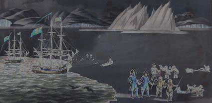
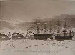
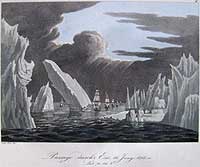
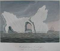
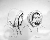
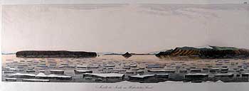
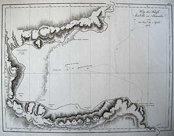
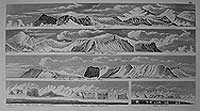
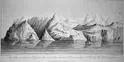
CAPE BYAM MARTIN, POSSESSION MOUNT AND CAPE FANSHAWE DISCOVERED SEPT. 1, 1818 BY HMS ISABELLA. 
Daniel Havell after John Ross. Original grey tint aquatint. 5 x 9 3/4" (12.5 x 24.6 cm) Ref. LRA arc 152/al/r.dosv>  DNN

This scene of brilliant white, towering conical mountains met Ross's gaze at the southern entrance to Lancaster sound. The awe-inspiring sight is reflected in the crystal clear water, then untravelled by known European explorers. Thirty miles further along, with fog rolling in, Ross without explanation, abruptly turned about and set sail for England. Admiral Sir Thomas Byam Martin, GCB. (25 July 1773 – 25 October 1854) was Comptroller of the Royal Navy. Published as plate #19 in the above work.


Ross ist. 8 Hopes Mon Lancaster snd

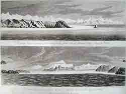
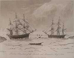
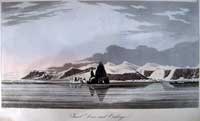
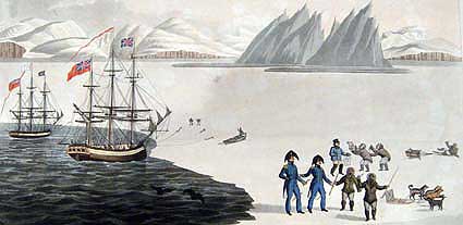
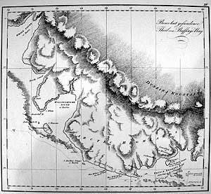
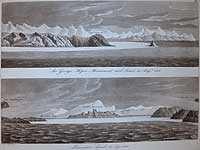
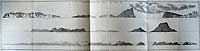
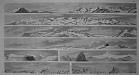
SIR GEORGE HOPE’S MONUMENT AND LAND, ON THE NORTH SIDE OF LANCASTER BAY AUG'T 30th. 1818 
together with 
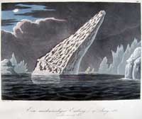
LANCASTER SOUND, AS SEEN FROM HMS. ISABELLA AT 3 PM AUG'T 31st 1818
Daniel Havell after John Ross. Original grey tint aquatints. Each 3 1/2 x 9 3/4" (9 x 24.8 cm) Ref. LRA  arc151/al/r.dosv>  ANN       

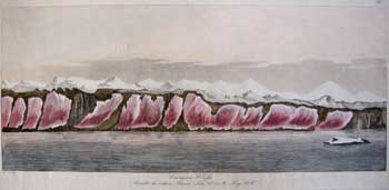
Shown in the lower panorama are the controversial Croker mountains which Ross alleged blocked westward passage from the sound. This was, in fact, the eastern entrance to the Northwest Passage.
“At half past two, (when I went off deck to dinner), there were some hopes of its clearing, and I left orders to be called on the appearance of land or ice a-head. At three, the officer of the watch, who was relieved to his dinner by Mr. Lewis, reported, on his coming into the cabin, that there was some appearance of its clearing at the bottom of the bay; I immediately, therefore, went on deck, and soon after it completely cleared for about ten minutes, and I distinctly saw the land, round the bottom of the bay, forming a connected chain of mountains with those which extended along the north and south sides. This land appeared to be at the distance of eight leagues; and Mr. Lewis, the master, and James Haig, leading man, being sent for, they took its bearings, which were inserted in the log; the water on the surface was at temperature of 34. At this moment, I also saw a continuity of ice, at the distance of seven miles, extending from one side of the bay to the other, between the nearest cape to the north, which I named after Sir George Warrender, and that to the south, which was named after Viscount Castlereagh. The mountains, which occupied the centre, in a north and south direction, were named Croker's Mountains, after the Secretary to the Admiralty. The southwest corner, which formed a spacious bay, completely occupied by ice, was named Barrow's Bay, and is bounded on the south by Cape Castlereagh, and on the north by Cape Rosamond, which is a head-land, that projects eastward from the high land in the centre. The north corner, which was the last I had made out, was a deep inlet; and as it answered exactly to the latitude given by Baffin of Lancaster Sound, I have no doubt that it was the same, and consider it a most remarkable instance of the accuracy of that able navigator. [Ross, pp. 174-175.]

Ross's description above of his infamous fictional "Croker Mountains" which dissuaded him from proceeding west and discovering the ultimate gateway of the Northwest Passage. Ironically, his error comes at the same time that he notes the accuracy of William Baffin's navigation! Published as plate #20 in the above work.

Rossist 9 ILN map baffin bay

I.L.N. Davis St. and Baffin Bay
MAP OF THE TRACK OF THE ISABELLA AND ALEXANDER IN 1818.
 Illustrated London News Ca. 1850.  wood engraving
 Double-matted 6 3/4 x 5" (7 x 12.6 cm) Ref.LRA-/-/a.dosn> RN

An attractively double-matted, reduced version of the Bushnan chart above this version was published in the Illustrated London News, circa 1850 shows place names and the track of the ships.

Ross Ist 10 Book Cover

KUPFERBAND ZU ROSS REISE NACH DEN POLARÄNERN 
[Charts and Plates to Ross’s First Arctic expedition 1818.]  

GERMAN EDITION Original boards and German printed pink title label. imperial folio, clean, all images printed on wove paper  
 Ref. LRAp arc135/ALNN/g.dosv.>LANN

On 18 April 1818 the ships departed; less than seven months later, they were back in the Shetlands, and Ross reported to the Admiralty in London on November 16. Generally, Ross's route had rediscovered Baffin Bay and it’s three important sounds duplicated Baffin's of 1616: a counter-clockwise circumference of Baffin Bay. They had sailed up the west coast of Greenland, reaching a latitude just above 77° N. 

As commander, Ross was offered a salary of £46 per month, able seamen £3. The selected ships, Isabella (385 tons) and Alexander (252 tons), underwent strengthening and reinforcing improvements inside and out; their combined twenty-six-month food allowance included over fifteen tons of bread, eight tons of beef in eight-pound pieces, 3500 pounds of lemon juice, and 1000 pounds of raisins. The Isabella carried an assortment of scientific instruments and a library of the published journals and accounts of earlier expeditions, such as those of Hearne, Mackenzie, Ellis, and Cook. Among items intended as gifts to natives on the west coast of Greenland and the coast of America were: 2000 needles, 200 looking-glasses (mirrors), 30 pairs of scissors, 150 pounds of soap, 102 pounds of snuff, 129 gallons of English gin, and 40 umbrellas. Accompanying Ross and his crew as an interpreter was John Sacheuse, a native of Greenland who, having been saved in a storm by an English ship several years before, had learned English and converted to Christianity.

Interactions with the natives, whom Ross called “Arctic Highlanders” and serious encounters with ice and icebergs had been the highlights of their journey. Unfortunately, after proceeding a few degrees into Lancaster Sound, being unwittingly deceived by a mirage, Ross turned the ships back out of the “bay,” claiming that he could see their way blocked by ice and what he named Croker Mountains [see ‘Lancaster sound’ image above]. This was the defining moment of the expedition, and their arrival back in England, Ross’s findings were initially accepted as conclusive and he was promoted to Captain. 

Shortly thereafter however, his findings were called into question and caused a considerable public controversy, for other officers, particularly those aboard the Alexander, felt a great opportunity had been lost because of an unsubstantiated observation. Ross was lampooned (see ‘Curious Dogs’ caricature below) and lost favour with John Barrow in the Admiralty. 

Ross himself felt that one of his voyage's major achievements had been the re-confirmation of William Baffin's geographical observations and the subsequent restoration of Baffin to a lofty place in the history of Arctic exploration. Ross's heavily illustrated expedition journal, with appendices full of zoological,  geological, and geographical data, became a model publication for subsequent British expeditions. 
Appended are various scientific and natural history notes. The beautifully coloured aquatint plates which illustrate the work were engraved by Havell after drawings by Ross, A.M. Skene, H.P. Hoppner, J. Sackhouse, D. Havell, Bushnan, & Thomas Lewin, are among the most striking and attractive plates created of the Arctic region. 

Note the first page number given is that of the description in Ross’s narrative Voyage of Discovery and Research within the Arctic Regions. London 1819, the second number is the image location in this German edition.
The 28 plates are as follows:

General Karte zur Entdeckungs Reise nach dem Nord-Pol von Capitain Ross im Jahr 1818. 
[A General chart the track and discoveries of H.M. Ships Isabella & Alexander to Davis’s Straights & Baffin’s Bay]  
German edition of Bushnan’s Davis Straight and Baffin Bay chart (see earlier entry for description).

I. Gardie House die residenz des Herren Wm Mount
[Gardie House the residence of Wm. Mouat Esq.] 
(see earlier entry for description). 18/2

II. Passage durch’s Eis, 16 Juny 1818 Lat 70.44’N. 
[Passage through the ice]
original colour aquatint. 46/12

Ross Ist book IIpassage through ice

Having fallen in with a fleet of Whalers, Rosses two ships threaded a passage through the curiously shaped icebergs, grateful for the experience of the ice pilot “We sailed on between large floes and among loose ice, which, as we advanced, became more numerous, and more closely packed, till at length we had only a narrow and crooked channel for our passage” p46 

III. Ein merkwürdiger Eisberg 17 Juny 1818 Lat 70°45’N 
[A remarkable iceberg, lat 70°45’N.]
Full original colour aquatint 47/13
 “At eight we saw a ridge of icebergs of every variety and shape that can be imagined.” p46 

ross ist Remarkable iceberg
IIII Insel Disco und Eisberge 
[Island of Disco and Icebergs]
 Full original colour aquatint, after a drawing by A.M. Skene. 50/15
Ross’s ships are seen, one moored to the iceberg in the foreground and the other in the shelter of a headland to the right. p48
Ross Ist DiscoIs

V Kallie, eine Frau aus Opernivich wohnhaft N.E.Bay 
[Kalie, native of Opernovick]
 Full original colour aquatint, after a drawing by H.P. Hopner. 55/18
“Two of these women, taller than the rest, were daughters of a Danish resident by a Eskimaux woman….. We soon became intimate with our visitors and invited them to into the cabin, where they were treated  with coffee and biscuit, and their portraits taken.” p55

Ross Ist Kallie native

VI Merkwürdiger Eisberg July 1818 Lat 74 & Long 65W. 
[Remarkable iceberg, latitude 74°]
Full original colour aquatint, after a drawing by Ross. 58/20
Members of Ross’s crew are seen beneath the natural arch of a large iceberg with the Isabella off to the right. “On the 21st. the fog still continued and intercepted our sight…. till four o’clock, when we were again made fast to a floe.” p63

ross1st remarkable iceberg

VII Die Mannschaft der Isabella und des Alexander eine Passage durchs Eis sägend. 
[Isabella and Alexander sawing the ice]
After the original drawing by John Ross. Original grey tint aquatint. (see earlier entry for description) 62/23

VIII Cape Melville und Melvilles Monument 
[Cape Melville and Melville’s Monument]
Full original colour aquatint, after a drawing by Ross.74/31
A very high snowy mountain seemed to form the summit of this immense barrier of ice, which led to a lofty promontory”. p74
One of Ross’s ships is seen bearing off to the right.

IX Gefährlivhe Lage der Isabella und des Alenander am 7 August 1818 [Perilious situation of the Isabella and Alexander] Original grey tint aquatint. (see earlier entry for description) 77/33

Ross 1st First communications

X Erster Verkehr mit den Eingebornen von Prince Regents Bay
[First communications with the natives, by Sacheuse] Full original colour aquatint, after a drawing by Sacheuse. 88/41
This magnificent image captures the essence of early British exploration to the Arctic and the clash of cultures.   Regarding the expedition ships the Eskimo inquired “What great creatures those were? “Do they come from the sun or the moon? “do they give us light by night or by day?”. The vessels are seen moored to the pack ice with kedge and ice anchors (a lookout stands on the fore top mast and another in the crow’s nest above him) a jolly boat is pulled up on the ice with a sailor on guard. Seven traditionally dressed Eskimo are seen during the first communication the indigenous natives had with European explorers, on Aug 10th.  1818.  Lt. Parry (left) & Commander Ross are depicted in full naval dress of the period, the christianized native interpreter, John Sac(k)heuse (in top Hat) is seen distributing presents of a knife, a striped shirt, strings of beads and a looking glass (mirror). Native sleds and dogs await nearby.  The whole scene is set amid the awe-inspiring desolation of ice bound Prince Regent’s Bay.
“I therefore desired Lieutenant Parry to accompany me to the place where the party was assembled, it appearing to me that Sacheuse [sic] had failed in persuading them to come nearer the ships. We accordingly provided ourselves with additional presents, consisting of looking-glasses and knives together with some caps and shirts” p86

 XI Ervick. Eingeborner aus Prince Regent’s Bay Lat 76 12N Long 65W. [Ervick, native of Prince Regent’s Bay]
Full original colour aquatint, after a drawing by Ross.95/46
“The three men remaining were now handed down to my cabin, and shewn the use of the chairs, which they did not comprehend, appearing to no notion of any other seat than the ground. Being seated we attempted to take their portraits” p93 

Ervick native

XII Marshuick Meigack
[Arctic Highlanders]
Etching after a drawing by A.M. Skene 95/46

We now ascertained their names, that of the eldest being Ervick, and that of the two others, who were his brother’s sons, Marshuick and Otooniah. Some jugglers’ tricks were afterwards exhibited by Mr. Beverly, which seemed to disconcert them, as they became uneasy and expressed a wish to go on deck.” p95
arctic Highlanders

XIII Spiess, Peitsche, Schlitten, Messer
[A bone Sledge, Dog Whip, Spear, Snow knife.]
Engraving after Daniel Havell 102/51
I received a spear, made of sea unicorn’s horn, with a sledge, made chiefly of the bones of a seal, tied together with thongs of seal skin, the runners, or lower pieces, being formed of sea unicorn’s horn.” p102 

sledwhipspear


Chart part of baffins Bay

XIV Bewohnt gefundener Theil von Baffings[sic] Bay. [Chart of Part of Baffin’s Bay found inhabited] 
Copper engraved map on watermarked ‘A. Hublr’ wove paper. Originally engraved by J. Walker and published by John Murray London 1819 8 5/8 x 9 3/8” (21.9 x 23.8 cm) 116/59
This German edition without imprint, but retains the original English nomenclature. The map shows the Arctic Highlands, location of the crimson cliffs and track of Ross’ ships skirting the ice from Prince Regent’s Bay to Cape Robertson. The area being noted by Ross as a seabird and sea mammal breeding ground. 

crimson cliffs

XV Crimson-Cliffs Ansicht des rothen Schnees Lat 76°25 N., Long 68°W [Crimson cliffs] 138/75
Full original colour aquatint/etching, after a drawing by Ross. Engraving after Daniel Havell

We now discovered that the snow, on the face of the cliffs, presented an appearance both novel and interesting, being apparently stained by, or covered, by some substance, which gave it a deep crimson colour.” p139. Although Ross was mocked for his theories (see Curious dogs caricature below) on this remarkable discovery, more recent scientific analysis has determined that the colouring was caused by the blooming of an ancient coralline red algae,and is colloquially refered to 'Watermelon ice'.

XVI Petoowack bildung eines Eisberges [Petowack, formation of an iceberg] Full original colour aquatint, after a drawing by Ross, after the engraving by D. Havell & Sons * 141/77
The iceberg depicted had been recently calved from the extensive glacier located six miles north of Cape Dudley Digges. p142 see earlier entry PETOOWACK. Formation of an iceberg.

Wolstenholme Sound

XVII Ansicht der Inselu im Wolstenholme Sound [Wolstenholme Sound]
Full original colour etching, after a drawing by A.M. Skene. and after the etching by D. Havell 142/77
Dalrymple Rock, Cape Stair and Booth’s Bay are seen within the sound.
“As we approached[sic} Wolstenholme Island and opened the sound of that name, I sent a boat to try to reach the shore, but a thick fog coming on I was obliged to recall her” p142

 XVIII Coburg Bay, Cape Leopold, und Princess Charlottes Monument [Cape Leopold, Coburg Bay]
Full original colour aquatint, after a drawing by Ross, and D. Havell & Sons. 161/91
 An immense glacier fills the background. “Off the southernmost point a very remarkable conical rock, with a small one near it, of similar form, was seen; and when abreast of it, a large bay, which was filled by a glacier, extending quite across it, was seen; this I named Cobourg Bay, and the headland before mentioned, Cape Leopold, in compliment to his Royal Highness the Prince Leopold. The remarkable rock near it was named Princess Charlotte’s Monument, after our lamented Princess.

Couburg bay

 XIX Cap Byam Martin, possession Mount, und Cap Fanshaw Entdeckt  den 1 September 1818 [Cape Byam Martin]* 170/96
Etching after sir John Ross. This image differs slightly from the one that appears opposite page 170 in the English edition of Ross’s Voyage of Discovery listed earlier, in so much, as this is an etching not an aquatint. The remarkable pair of rocks in the shape of human figures form the peak of the mountain to the far right.

Cape Byam martin

XX Sir George Hope’s Monument und Land 30 Augt. 1818 /Lancaster Sund 31Aug.1818. [View of Lancaster Sound]* 174/99
Daniel Havell after John Ross. Original grey tint aquatints with English nomenclature.  Again, the infamous view of the fictional Croker mountains blocking the entrance to Lancaster sound that cost Ross his early reputation and career. (see earlier entry) A pity, as many of his other discoveries and accurate observations proved to be of considerable scientific and geographic importance. 

hope& Lancastersounds

Track of ships

XXI Weg der Schiffe Isabella und Alexander, von 29 august bis 1 September 1818 [Track of H.M.Ships Isabella & Alexander from 29th. August to the 1st. September1818.  Chart of Lancaster Sound] 175/100 
Plate size 10 3/8 x 13 3/4” (26.3 x 34.9cm.)
Original Copper engraved chart after that of J. Walker, published by J. Murray Feb 1818 which shows the track of the two expedition ships standing off the sea ice of Lancaster sound which Ross was convinced was blocked by the Coker Mountains. He did take soundings and bottom water temperature, despite the considerable swell and then decided to move on. 
Compare. Cartographica #6 Map 6

XXII Ansichten von Land in Davis-strasse und Baffins Bay [Views of the land in Davis Strait and Baffins Bay Cape Graham Moore, Etc.] 192/107
Original Copper engraved perspective view after that of J. Bushnan, published by J. Murray Feb 1818.  34 1/2 x 8” (87.7 x 23 cm.)
This splendid perspective of the coast line comprises of five views spread over two conjoined plates. “I gave the name of Coutt’s Inlet; and to the capes which formed its entrance, that of Coutts’ to the north, and Antobus to the south: a view of this part of the coast was taken by Mr. Bushnan.” p.191

Davis St & Baffin bay views

XXIII Ein Schlitten-hund. Kopf eines weissen bären [Dog and Bear’s Heads] 199/113
Splendid sepia aquatints depicting a sledge dog of the Arctic Highlands of Lat. 77 N. and the head of a white bear. after the original drawings by AM. Skene. The polar bear weighing over 1131 ½ Lbs. was preserved and sent to the British Museum. It has now been genetically proven the ALL polar bears evolved from one small pioneering group of Irish Brown bears that split off from the main 'sleuth' during the last ice age (111 to 166 thousand years ago) and adapted to the Arctic cold becoming the iconic Polar bears of today.

The dog was apparently the size of a shepherd’s but with a head like a wolf and a tail of a fox with the cry of false bark of the latter and the howl of the former. p133

Dog and Bears head

XXIV Ein Bär ins Meer stürzend [Bear plunging into sea]
Full original colour aquatint, after a drawing by Ross. Engraving after Daniel Havell  208/119
A splendid action image of a polar plunging into the sea from an iceberg after being frightened off by a musket discharged from the quarter deck of the Isabella. The bear escaped without harm. p208

Ross ist Bear jumping

 Images from the appendix 


 XXV Xeme [Xeme]  lvii/142
Drawn and engraved by Thomas Lewin
 The Xeme  Leach. The genus approaches to the gull in the form of its beak, and to the tern in having a furcate tail, as well as in the general form and proportion of its legs. lvii

Ross ist Xemebird
XXVI Eingang der Waygatt Stasse, und sonstige Ansichten [Views of Headlands.] ross 1st views of headlands 1
XXVII Cape York, und sonstige Ansichten [Views of Headlands.] Ross 1st headlands 2

Ross!st Curiius Dogs

CURIOUS DOGS from the North Pole; or the return of the Arctic Expedition!!
Yedis invt. [Charles Williams] Published J. Sidebotham 287 Strand. [?Jan 1819] 
VERY SCARCE, Excellent condition, good margins, original hand tinted engraving
8 ¾ x 12 ¾” (22.4 x 32.5cm.) inc. letters
 Ref. LRA Arc-p88/ALS/ a.dnsg> VNN

Upon the return of Ross's expedition to London on 16 November 1819 Ross was lampooned and depicted in caricature such as this now very scarce example by Charles Williams.   The procession, which caricatures the crew of Capt. John Ross returning from their Arctic expedition of 1818, is passing small old-fashioned houses (left) with casement windows, and the ship, which is on the extreme right, and in the background, is on wheels. In front of the houses stand spectators. Ross is seated in a sledge drawn by four dogs; he holds a flag: 'GPR / Sovereign / of the / Pole'. He sits on his 'Log Book' which rests on a box of 'Grog'. Beside him is a large rolled 'Plan of the Ice . . .' The accompanying sailors are mounted on bears and are noseless, (nose-pulling was a friendly Eskimo greeting). The first has a basket labelled: 'Red Snow balls for P.R' [Prince Regent]; he says, waving his hat: "Come Push on Mr Bruin or we shall have the snow balls run through the basket." Another has a similar basket labelled 'Blue Snow for PR'. A third, in the foreground, clings jovially to the neck of a brown bear on its hind legs; on the ground lie his whip and basket, filled with ice and labelled 'Polar Ice for PR'. On the extreme right is a fourth, his basket labelled 'Polar Iron for PR'. Beside Ross's sledge is a covered van, with dogs poking their noses through the bars which form the front of the van. On the top sits a sailor holding a flag: 'Dogs to be killed to save the Nation the expence of feeding, and stuff'd with straw for the British Museum'. He looks round to say: "Why Jack your Bear has a mind to turn gentleman and walk upon two legs like Christian Bears!" The van is drawn by two miserable horses led by a wagoner in a smock. In front of the procession run a sailor lashing the dog-team, and carrying a huge tusk on his shoulder labelled 'Tooth of the Mamoth' [sic]. A huge whale, labelled 'Whale for Lord Cas[tlereagh]', is slung horizontally from one of the masts of the ship; sailors haul it up (or down). There is also a basket of 'Seals for L . . .' 
Despite bringing much useful scientific information, specimens and observations back from the Arctic the social media and press were vicious (then, as now). Caricature was the popular mode of attack, subsequently contemporary caricatures such as this, have become very scarce and highly collectable.  

Vide: Catalogue of Political and Personal Satires preserved in the Department of Prints and Drawings in the British Museum / by Mary Dorothy George, v. 9, no. 13195

To purchase the original antique Maps and Prints of section 10 Contact us
© Darrell G. Leeson MMXVII1