|
 |
|
|
|
 |
|
 |
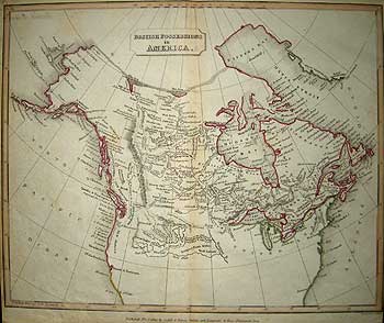
SECTION 9 THEY CARRIED THE ECONOMY OF A NATION ON THEIR BACKS.
Fur Trade Rivalries and Western Survey and Expansion 1780-1823
The inland and coastal explorations of the 18th century led to the delineation of much of the Pacific coast and defining the major water routes of the interior. At the turn of the century however, much interior detail remained to be filled in. The power struggle for dominance of the inland fur trade between the competing Montreal based X-Y Co., Fort William based North-West Company and London based Hudson's Bay Co. continued, with servants from each company no longer maintaining friendly relations between each other. More and more frequently, tales of violence, murder and vicious rivalry were reported. Supply lines to those exploring the vast unknown interior for new fur limits and new native trading alliances became extended, to the point where some winter supplies to the far distant trading posts never arrived.
Coinciding with the change of policy by the H.B.C. to move inland from the Bay environs, (see section 8) was the improvement in survey instruments and mapping techniques. Demands were placed on all three companies to find and train personnel in the new methods, as the need for more accurate maps became apparent, at least to company headquarters, if only to locate newly established trading posts. Some like Philip Turnor, the first scientific observer of the western interior and Alexander Mackenzie were trained surveyors; others, as in the case of Little Bear, were native mapmakers. The majority were apprentices.
David Thompson (1770-1857) was seconded from the Grey Coat School, Westminster, by the H.B.C. at the age of 14. After first transcribing Governor Hearne's 'Journal' (see section 2) whilst at Fort Prince of Wales, he was transferred to Cumberland House in 1789. There he was apprenticed to Turnor, the Company's Chief Surveyor. At 21 Thompson had completed his seven-year apprenticeship and was given a contract as a surveyor/trader. A consummate surveyor and astronomer, Thompson was to become one of Canada's greatest pioneer surveyors. In March 1797, following a dispute with the H.B.C., he transferred his allegiance to the N.W.Co., his remarkable surveys earning him a partnership at age 34. As with his contemporary Beethoven, fate was to play a cruel trick, for Thompson spent the last ten years of his life totally blind and virtually destitute. His monument is his many fine maps, the greatest of which, the first comprehensive map of western Canada is housed in the Ontario Archives.
Another amongst the surveyor/trader/explorers in the field, was Peter Fidler (1769-1822) who, like Thompson, was apprenticed to Philip Turnor. Four years after his mentor's retirement, Fidler was appointed Chief Surveyor and Mapmaker to the H.B.C. Apart from generating maps of his own explorations Fidler transcribed many Indian maps. Following the establishment of Chesterfield House (1800), and completing surveys in both the Assiniboine and Kildonan areas, he was appointed surveyor to the Selkirk Settlement, where he oversaw the laying out of river lots between 1813-17.
|
 |
|
 |
|
|
|
|
|
 |
|
 |
Many of the maps prepared by both Thompson and Fidler for the H.B.C. were forwarded to London where Aaron Arrowsmith, the company's choice of unofficial cartographer, expertly compiled the field office manuscript maps into pleasing, accurate and fine cartographic examples. The original segments were retained by the H.B.C. (now transferred to the Company frond, Public Archives of Manitoba).
The number of men employed by the two main fur trading companies was surprisingly small: 500 for the H.B.C., of which 318 were stationed inland, against 903 out of the total of 1,276 N.W.Co. employees in 1799. Nevertheless, it was the vast distances of the supply lines involved that not only lead to tensions but eventually forced amalgamation.
In 1803, the United States made the Louisiana purchase from France, and dispatched Lewis and Clark on their overland journey to the Pacific within the year. This spurred the North West Company to survey similar trade routes of its own to the Pacific to compete with the Americans. From its entrepôt at Thunder Bay, the efficient N.W.Co. could move more swiftly to exploit new opportunities than the London-based Hudson's Bay Company and both Simon Fraser and David Thompson opened up important new overland routes to the west coast and established trading posts for the N.W.Co.
This was the most profitable period for the North West Co. Especially after 1804 when the ‘X-Y’Co. and N.W.Co. buried their fierce rivalry and amalgamated, thus creating a monopoly in the Athabaska District which they held until 1819, despite repeated failed attempts by the Hudson's Bay Company to encroach upon their trade. Between 1810-15 however, N.W. Co. trading in the Mackenzie District declined, resulting in the closure of many posts.
Over extended supply lines to the new limits proved a drain on the resources of both companies. Not only were an inadequate number of transport canoes available, but critical shortages of armaments and recruits were created by the American War of Independence and Napoleonic Wars in Europe.
In June 1811 the Hudson's Bay Company granted a large tract of land from Winnipeg to Rainy Lake to the Earl of Selkirk for the establishment of a colony known as the Selkirk or Red River Settlement. The subsequent influx of colonists and settlers via York Factory and the Winter Road (constructed 1813) provoked bitter opposition from both H.B.C. and N.W.Co. traders, as it cut across established trading routes. Tensions between the rivals came to a head in 1816 when the H.B.C. moved to block the N.W.Co’s supply of pemmican, which they purchased from the Métis of the Red River valley. A confrontation between the Métis and the H.B.C. near Portage La Prairie, the so-called ‘Pemmican War’ of 1816, resulted in the deaths of 21 men and kicked off years of lawsuits until in 1821, with their financial resources exhausted, both rival fur trading companies agreed to amalgamate.
1811 was also the year of the Moravian Mission to Ungava Bay, whose missionary - explorers prompted further penetration of the virtually unknown northern Quebec-Labrador peninsula, particularly by James Clouson of the Hudson’s Bay Company in 1819-20.
|
 |
|
 |
|
|
|
|
|
 |
|
 |
The peace in Europe and many of its colonies, following the Napoleonic wars, left Britain with a powerful and confident Royal Navy and a surfeit of eager officers keen to seize an opportunity to make a name for themselves. The further exploration of the world’s oceans, under the auspices of a now streamlined, volunteer Royal Navy, which swiftly adapted to its new role of peace-keeper, empire builder and scientific explorer, provided just the sort of challenging opportunity for heroism-without-militarism (and the chance of swift promotion) its officers needed.
The impediment posed by the ice bound landmass of North America in the search for a Northwest Passage to the Orient had all but ended official government-sponsored expeditions and explorations in the 18th Century (the torch being carried by the H.B.C. and commercial interests of whalers). However, William Scoresby, Jr. (son of the inventor of the crow’s-nest), probably the foremost Arctic ice authority and experienced northern navigator in the early 19th. century, reported in 1817 to Sir John Barrow, (the single minded and Admiralty Secretary and founder of the Royal Geographical Society 1830), that Arctic waters had been comparatively ice free for two seasons.
References cited:
Historical Atlas of Canada Vol I From the beginning to 1800. University of Toronto Press. Toronto 1987.
Munro, Geo. Picturesque Canada: The country as it is and was. Beldon Bros. Toronto 1882.
John Barrow, A Chronological History of Voyages into the Arctic Regions, undertaken chiefly for the purpose of discovering a north-east, north-west, or polar passage between the Atlantic and Pacific. J. Murray London 1818
Lopez, B. Arctic Dreams C. Scribner's sons, New York 1896.
Sabin J. Bibliotheca Americana, A Dictionary of Books relating to America. New York 1868-1936
Cartographica Explorers maps of the Canadian Arctic 1818-1860. Monograph No 6. York University, Toronto 1972.
|
 |
|
 |
|
|
|
|
|
 |
|
 |
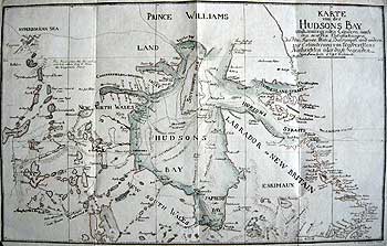
[ZIMMERMANN] Northeast Canada
KART von der HUDSONS BAY und den umliegenden Ländern.nach den neuesten untersuchungen der Hln Turnor, Wales, Dalrymple und andern zur Erläuterung von Umfrevillens Nachruchten über diese Gegenden.
[EBERHARD AUGUST WILHELM VON ZIMMERMANN] Helmstädt 1791
Ist German issue with Manuscript additions. Copperplate engraved map with original hand tinting. Printed on watermark laid paper.
8 x 13" (20.5 x 33 cm.) Ref.LRA732/VL/dd.dosd >ESL
A finely engraved map in pleasing and subtle original outline colour with manuscript additions. It was prepared by Zimmermann for Edward Umfreville, "Den Gegenwärtigen Zustand der Hudsoon Bay...," Helmstädt 1791, Ist. German edition, the plate being engraved by Christian Gottlieb Reichard (1758-1837) and adapted from the important world chart of Aaron Arrowsmith (1790 [1]) The interior delineation of northern Canada was in turn based on the explorations of Philip Turnor 1785, William Wales 1768-9, and the East India Co. and Admiralty Hydrographical offices' observations under Alexander Dalrymple.
The considerable number of early and unusual place names identify the known topographical features and early trading posts. Also shown are the exploratory routes of Hudson, James, Middleton, Hearne, Moor and Smith.
It is one of the first maps to show detailed information of Samuel Hearne's discoveries on a map of Canada.
There are a number of printed errors as to the dates of certain discoveries, i.e.: Frobisher's strait (Bay) 1567 and Cumberland Strait (Sound) 1555 which should read 1576 and 1585 respectively. This map has the added interesting feature of four contemporary manuscript additions of supposed discoveries in:
1) The present - day Maguse Lake- Eskimo Point area.
2) The Nueltin/Henik Lakes/Tha-Anne/Thlewiaza Rivers system which are here shown as one huge lake named 'Shetung [?] Lake' (possibly derived from Hearne's 1769-72 discoveries. A more likely source for this addition however, is the scarce map by Vasily Berkh (1808), published to accompany the account of the Russian voyage of I.F. Krusenstern and Y.F. Liskiansky in the Nadezhda and Neva 1803-6).
3) Incorrect location of Manchester House (first established by David Thompson in 1786 and re-established in 1793) on an extended Saskatchewan River. (The post's first public appearance on a map was on that of Turnor of 1790.
4) A note on the verso regarding Cape Stanhope on Chesterfield Inlet.
Edward Umfreville had been a Hudson's Bay Company servant 1771-82, during which time he was captured at York Factory/Fort by La Pérouse. After his release, he became a critic of the Hudson's Bay Company and later explored and traded west of Lake Superior for four years on behalf of the North West Co. until 1788. He published his controversial The present state of Hudson’s Bay . . . London, 1790
Vide: Jesuit Relations, p.315
James Ford Bell Library annotated Catalogue, p.467
|
 |
|
 |
|
|
|
|
|
|
|
|
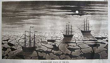
MOONLIT SCENE ON THE ICE
THOMAS Mc KEEVOR London [1819/20]
Rare, sepia tint aquatint printed on 1818 watermarked wove paper.
4 1/8 x 7 1/8" (10.5 x 18.2 cm.) Ref. LRAp Arc3/S.LN/e.dosl>ANN
This is a fine, dark impression of a rare aquatint engraved by Neele & Son, probably from a drawing by Thomas McKeevor. It was published in McKeevor, T. A voyage to Hudson's Bay during the summer of 1812, Sir R. Phillips, London 1819, which later appeared in Sir Richard Phillips New Voyages and Travels consisting of Originals and Translations. Vol.II, London 1820-3.
Depicted is the scene on or about 19 July 1812, when Hudson's Bay Company supply vessels 'Robert Taylor' (Capt. John Davidson), 'King George' (Captain John Turner) and 'Eddystone' (Capt. Thomas Ramsey) were delayed by field ice en route to Hudson Bay. In the foreground may be seen 'Robert Taylor' with kedge anchors deployed and crew members clambering over the ice floes.
This is an aquatint of considerable feeling. A scene captured by someone who could only have had a first-hand experience of the ethereal qualities produced by the Arctic environment. The very eerie qualities of moonlight on ice, the stillness of the polar Arctic air on a calm night, distance of vision, punctuated by the cracking of the ice floes under pressure are all here portrayed.
Thomas McKeevor, a doctor from the Lying-In hospital, Dublin, Ireland was appointed doctor to the Selkirk Settlement. He was en route with the first shipload of colonists under the charge of Owen Keveny, for the settlement at the Red River. The 'Robert Taylor' arrived at York factory 16 August. The colonists departed thence by 9 September and arrived at the new settlement 27 October 1812.
1815 saw an end to the Napoleonic wars and the US./Canadian War of 1812 and the return of peace. It also provided an opportunity for officers of Britain's Royal Navy to distinguish themselves. Sir John Barrow, as Admiralty secretary, used his position to direct naval voyages of exploration for renewed state interest in the discovery of a North West passage, which by then was known must lie north of 68°N. As added incentives, £5,000 was to be awarded to the first ship to sail within 1° of the North pole over and above the £20,000 to be awarded to the discoverer of the 'Passage' (not necessarily through Hudson Bay). Further, another £5,000 was to be awarded to the first ship to sail past 110°W, as the position could now be calculated with accuracy, thanks to the 37 year struggle to develop a reliable chronometer by a civilian named John Harrison (and to be paid for it.)
Unfortunately, a result of the supremacist arrogance of the Royal Naval mindset being the belief that rank and social position would triumph over practical experience (oft at their peril as Franklin was to find out), Secretary Barrow therefore ignored, for the most part, much possible useful advice from fishermen who annually visited the area or the native peoples, familiar with the topography and geography, who had lived in the region for generations. The expertise of William Scoresby was largely ignored since he was not a navy man and was therefore shunned by the intransigent Barrow.
Sabin Biblioteca Americana 43396
|
|
|
|
|
|
|
|
|
|
|
|
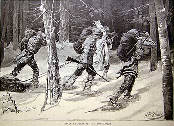
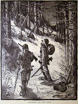
Although these next few images are from later in the 19th. cent. it seems appropriate to include them here.
AT THE PORTAGE
Hudson's Bay Company's Employés [sic] on their annual Expedition.
F.W.? OGDEN Toronto 1872
Wood engraved lithograph. published in Picturesque Canada 1872
9 x 6 3/8" (22.7 x 16.2 cm.) Ref. LRA-/dn/ d.dosl >DNN
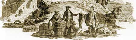
The intrepid explorers aside who are known to our history, but make no mistake about it, it was the voyageurs, trappers, Métis and native Indian guides and countless unnamed others, seeking honest employment and dignity of purpose, that helped make this nation by ‘carrying the early economy of a nation, on their backs’ across the Petit & Grand Nord of Canada around the turn of the century. This scene is typical of the trans-shipment of trade goods along the network of inland waterways of the boreal forests and grass & parklands from the shores of Lake Winnipeg to Hudson Bay and Lake Superior to the St. Lawrence. The employees of H.B.C. who had perfected the shallow-draft ‘bateaux’ and the N.W.Co. the ‘Canots du nord’ used such ideal vessels for traversing the often dangerous inland waterways. In such manner were some 50,000 pelts transported annually, but had dropped to 7,000 by the time of amalgamation.
The profits generated were huge, up to £70,000 a season of mainly Muskrat, Marten and Beaver resulting in the eventual de-population of the fur bearing mammals and the inevitable fall in profits. Not to mention the impact on the native peoples as company trade goods irrevocably changed native hunting methods and influenced Indian culture throughout Northern Canada.
Depicted in this scene is a half size H.B.C. birch-bark canoe, approx. 24 feet in length with a six ft. beam and capable of carrying about two tons, besides the crew. A full sized canoe could carry double the capacity. "The 'pieces' or wrapped packages of goods, each made to weigh 100 pounds, were portaged by the voyageurs to the water's edge by means of their pack-straps, trump lines, or slings of stout leather passed over their forehead. The guide or steersman giving each man a hand-up with his piece is accompanied by his squaw who is patiently waiting with her papoose slung on her back in its Indian cradle" Picturesque Canada p.305.
|
|
|
|
|
|
|
|
|
|
|
|
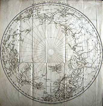
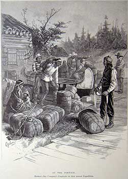
WALKER -Arctic Regions
MAP OF THE ARCTIC REGIONS
J. WALKER London 1818
Copper engraved map on wove paper
12 x11 ½” (30.5 x 29.3cm.) Ref. LRA m814/DNN/a.dosa>RVL
In 1818 Sir John Barrow, secretary of the Admiralty, published his A Chronological History of Voyages into the Arctic Regions, undertaken chiefly for the purpose of discovering a north-east, north-west, or polar passage between the Atlantic and Pacific.J. Murray London 1818. It summarized the many voyages that had been made to the arctic regions to that date. The map accompanying the 'History' illustrates the extent of geographical knowledge, thereby serving as a cartographic baseline from which to measure subsequent voyages and discoveries. As shown by the map, "the true nature and complexity of the Arctic lands was completely unknown and the northernmost limits of the continent of North America were only conjectural" Cartographica, p. 2
Nevertheless, it seems extraordinary that an authoritative enthusiast of the caliber of Sir John Barrow would leave so much blank space north of Davis Strait. In text to his book he endorses the discoveries of Baffin as a great achievement, and yet they do not appear on his map at all - faint praise, indeed. Baffin's discoveries had come to be disbelieved by early 19th century cartographers, perhaps because they tended to discourage ideas of an easy solution to the North-West passage problem, and that was not what Georgian England wanted to hear at the dawn of a new age of empire building. For Baffin however, vindication was close at hand. (see section 10)
Here delineated are the early European discoveries together with fruits of the long and extremely arduous task, costing hundreds of lives, that faced the Great Northern Expedition, and subsequent 18th century expeditions to map the Asian Arctic, along with those discoveries along northern and Pacific coast line of America. But now, with Napoleon dying slowly on the island of St. Helena (probably with the aid of a poisoner's hand), the stage was now set and Britain could turn the attention of her ambitious naval officers to the discovery of her unknown Canadian Arctic realm.
Ref. Cartographic #6 Map 1
To Purchase the original antique Maps and Prints of section 9 Contact us
© Darrell G. Leeson MMXVII
|
|
|
|
|
|
 |