![]()
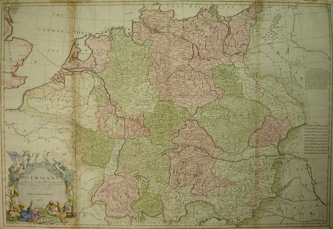
John SENEX GERMANY
GERMANY Corrected from tha observations of the Royal Society at London and the Royal Academy at Paris by John Senex FRS. 1710 Iohan Senex sculpt.
Copperplate engraved map with original hand full body colour. Ornate title cartouche (Bottom Left) incprporating allegorical human and putti figures. ( Tinting of title cartouche by another hand.) Some browning and separation along one fold.
25 1/2 x 37 5/8” (64.8 x 95.6 cm)
Ref. DB 5 /RLN /a.sn > SLN
A large and impressive map of Germany from John Senex’s, very rare 'English Atlas', which was first issued from about 1710 as a collection of maps but not with a title page until 1714. the map being printed on two sheets and then joined. Ten scales of miles & leagues. The large scale allows for considerable detail incorporting both topographical features ; Large & smaller towns and villages, together with political boundaries and the track of Dr. Brown from Norwich through Germany. Depicting the area extending west to east from London to Warsaw and north to south from Sleswick to Venice. The map could easily be improved by conservation attention. Even in its present overall moderate condition it is still a great buy of an increasingly scarce map.
John Senex 1678 -1740 was an astronomer and map maker, and was also an engraver, publisher of globes and maps, surveyor and geographer to Queen Anne. A contemporary of Hermann Moll, and his work bears some resemblance to that of his colleague. In conjunction with Charles Price and James Maxwell (1708-14) he produced some fine maps of the world and the continents as well as loose maps of various countries. Apart from these he seems to have had a particular interest in road maps and in 1719 he issued a corrected edition of Ogilby's 'Britannia' in miniature form which went through many editions.
Home | Contact | Location | Links | Antique Prints | Fine Art | Antique Maps | Omnium Gatherum | Specialty Services